Thirteen Original Colonies Map Worksheet | Student Handouts
 
Thirteen Original Colonies Map Worksheet
www.studenthandouts.com ↣ U.S. History ↣ Colonial Period Educational Resources ↣ Colonial Period Worksheets
 
 
Thirteen Original Colonies Map Worksheet - Free to print (PDF file). We recommend that educators check out these other free teaching materials our experts have created.

Middle Eastern Conflict Writing Exercises

Early Peoples through the Agricultural Revolution Outline
 
 
Click here to print.

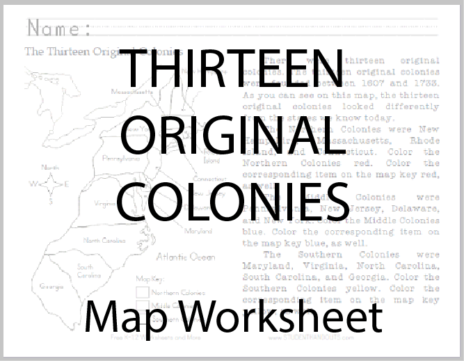
There were thirteen original colonies. The thirteen original colonies were founded between 1607 and 1733. As you can see on this map, the thirteen original colonies looked differently from the states we know today.

The Northern Colonies were New Hampshire, Massachusetts, Rhode Island, and Connecticut. Color the Northern Colonies red. Color the corresponding item on the map key red, as well.

The Middle Colonies were Pennsylvania, New Jersey, Delaware, and New York. Color the Middle Colonies blue. Color the corresponding item on the map key blue, as well.

The Southern Colonies were Maryland, Virginia, North Carolina, South Carolina, and Georgia. Color the Southern Colonies yellow. Color the corresponding item on the map key yellow, as well.

Click for our free common Core printables for: Primary Social Studies.
 
 
Free K-12 Education Resources
 
 
Colonial Period Books and FilmsColonial Period Educational Games
  
Colonial Period Image GalleriesColonial Period Outlines and PowerPoints
  
Colonial Period MiscellanyColonial Period Worksheets
 
 
www.studenthandouts.com ↣ U.S. History ↣ Colonial Period Educational Resources ↣ Colonial Period Worksheets
 
 
Free Printable Brain Teaser and Head Scratcher Worksheets for Kids and AdultsFree Printable Holiday Worksheets
 
 
100% Free Handwriting Practice Printables - Print and Cursive