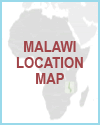
Malawi is a landlocked country in southeastern Africa, bordered by Tanzania to the north, Mozambique to the east and south, and Zambia to the west.
A defining feature of Malawi's geography is Lake Malawi, which stretches along its eastern border and is one of the largest lakes in Africa.
The Great Rift Valley runs through the country, creating highland areas and deep valleys.
The terrain includes plateaus, rolling plains, and mountainous regions such as the Nyika and Mulanje ranges.
The Shire River flows south from Lake Malawi and is an important waterway.
Malawi's climate varies from tropical to subtropical, with a rainy season from November to April and a dry season the rest of the year.
The geography supports a largely agricultural economy and contributes to the country's rich biodiversity.
Malawi's landscape plays a central role in its culture, economy, and way of life.
|


