Maps and pictures are powerful tools that can greatly enhance high school World History students' understanding of the European Enlightenment. This period, filled with new ideas about government, reason, science, and human rights, can sometimes feel abstract. Visual resources help bring those concepts to life by providing tangible context and making complex developments more relatable.
Maps from the Enlightenment era allow students to see how Europe was politically and culturally divided during the 17th and 18th centuries. They can trace the spread of Enlightenment ideas across countries and visualize where key figures such as Voltaire, Locke, Rousseau, and Kant lived and worked. These geographic insights help students connect ideas to specific places and events, deepening their understanding of how intellectual movements were shaped by local and national circumstances.
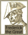
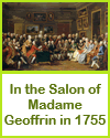
Pictures--including portraits, historical paintings, and illustrations--can make abstract philosophies feel more personal and grounded. Portraits of Enlightenment thinkers humanize them, while paintings of salons, scientific experiments, and revolutionary moments illustrate how ideas were debated and applied in society. Political cartoons and satirical drawings from the period also provide insight into contemporary reactions to Enlightenment ideals.
By engaging visually with history, students can better retain information, draw connections, and develop a clearer picture of how the Enlightenment transformed Europe and the wider world.
|