


| Ancient Israel-Palestine Map Worksheet |
|---|
| www.studenthandouts.com ↣ World History ↣ Ancient Near East Teaching Materials ↣ Ancient Near East Worksheets |
 |
    |
|
Click here to print this geography worksheet on ancient Israel-Palestine.. Click here for the answer key.
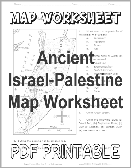
1. What was the capital city of the kingdom of Judah? a. Jerusalem b. Nazareth c. Sidon d. Tyre 2. What large body of water lies just east of Jerusalem? a. Dead Sea b. Euphrates River c. Gulf of Akabah d. Mediterranean Sea 3. Ancient Phoenicia was located south of Israel. a. True b. False 4. Color Phoenicia purple. 5. Color Israel yellow. 6. Color Judah green. 7. Color the following blue: (a) Dead Sea, (b) Euphrates River, (c) Gulf of Akabah, (d) Jordan River, (e) Mediterranean Sea. 8. Outline the dominion of Solomon in red. 9. Approximately how many miles are there between Jerusalem and Nazareth? a. 25 b. 50 c. 75 d. 100 |
| www.studenthandouts.com ↣ World History ↣ Ancient Near East Teaching Materials ↣ Ancient Near East Worksheets |