Map of the Aurignacian Age in Europe | Student Handouts
 
Welcome to Student Handouts--www.studenthandouts.com! 100% free teaching materials for students in kindergarten through high school--lesson plans, worksheets, PowerPoints, outlines, interactive games, puzzles, and so much more!
 
Map of the Aurignacian Age in Europe
www.studenthandouts.com > World History > Early Humans > Early Humans Maps and Pictures
 
 
Map of the Aurignacian Age in Europe
 
 
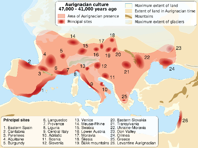
Click here to enlarge this map.

The Aurignacian culture was located across southern Europe, into southwestern Asia.

These people are commonly known as Cro-Magnons, or European early modern humans.

Principal sites: (1) Eastern Spain; (2) Cantabria; (3) Pyrenees; (4) Aquitaine; (5) Burgundy; (6) Languedoc; (7) Provence; (8) Liguria; (9) Central Italy; (10) Adriatic; (11) Bosnia; (12) Slovenia; (13) Venice; (14) Meuse-Rhine; (15) Swabia; (16) Lower Austria; (17) Moravia; (18) Silesia; (19) Büuk Mountains; (20) Eastern Slovakia; (21) Transylvania; (22) Ukraine-Moravia; (23) Don Valley; (24) Crimea; (25) Greece, and (25) Levant.
 
 
Free K-12 Education Printables and More
Final Exams Word Search Puzzle
Textbook Vocabulary Word Boxes Worksheet
Free Printable Crossword Puzzles for K-12 Education
One, Two, Buckle My Shoe Nursery Rhyme Worksheet
United States Trading Partners Chart Worksheet
 
 
Early Humans Books and Films Early Humans Outlines and Powerpoints
   
Early Humans Maps and Pictures Early Humans Online Study Games
   
Early Humans Miscellany Early Humans Worksheets
 
 
Map is modified. Source for the original is Wikimedia Commons.