


| Madagascar Map Worksheet |
|---|
| www.studenthandouts.com ↣ World Geography ↣ African Geography ↣ Eastern Africa ↣ Madagascar |
 |
   |
|
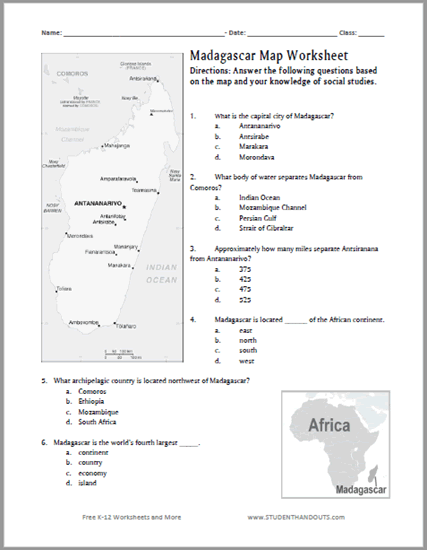
Click here to print this Madagascar map worksheet. Click here for the answer key.
Directions: Answer the following questions based on the map and your knowledge of social studies. 1. What is the capital city of Madagascar? a. Antananarivo b. Antsirabe c. Marakara d. Morondava 2. What body of water separates Madagascar from Comoros? a. Indian Ocean b. Mozambique Channel c. Persian Gulf d. Strait of Gibraltar 3. Approximately how many miles separate Antsiranana from Antananarivo? a. 375 b. 425 c. 475 d. 525 4. Madagascar is located ______ of the African continent. a. east b. north c. south d. west 5. What archipelagic country is located northwest of Madagascar? a. Comoros b. Ethiopia c. Mozambique d. South Africa 6. Madagascar is the world's fourth largest _____. a. continent b. country c. economy d. island |
| www.studenthandouts.com ↣ World Geography ↣ African Geography ↣ Eastern Africa ↣ Madagascar |


