Note: Our materials for geography education do not strictly follow physical location. As can be seen, we have placed Mexico in our unit on Latin America, for historical and linguistic reasons, rather than in North America. Hence, this unit is titled "Northern America" rather than "North America." When teaching this subject area to students, educators are free to organize their Geography course as they see fit.
North America, the third-largest continent, boasts a diverse array of geographical features, ranging from vast mountain ranges to expansive plains and extensive coastlines. The continent is bordered by the Arctic Ocean to the north, the Atlantic Ocean to the east, the Pacific Ocean to the west, and the Caribbean Sea and Gulf of Mexico to the south.
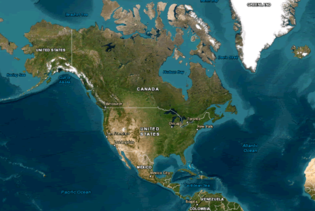 One of the most prominent features is the Rocky Mountains, stretching from Canada through the United States to Mexico, offering dramatic landscapes and significant biodiversity. To the east, the Appalachian Mountains, older and more eroded, extend from Canada to Alabama, characterized by their rich forests and scenic beauty.
The Great Plains, located between the Rockies and the Appalachian Mountains, are vast, fertile grasslands that support extensive agriculture and ranching. Further north, the Canadian Shield, a massive area of ancient rock, forms a rugged terrain rich in minerals.
North America's extensive river systems include the Mississippi-Missouri River, one of the longest in the world, and the Mackenzie River in Canada, vital for transportation and ecosystems. The Great Lakes—Superior, Michigan, Huron, Erie, and Ontario—are the largest group of freshwater lakes globally, supporting major industries and providing drinking water to millions.
Coastal features such as the Gulf of Mexico and the Baja California Peninsula add to the continent's geographical diversity, supporting unique ecosystems and significant economic activities like fishing and tourism. Overall, North America's varied geography shapes its climate, natural resources, and human activities, contributing to its rich environmental and cultural tapestry.
|







 One of the most prominent features is the Rocky Mountains, stretching from Canada through the United States to Mexico, offering dramatic landscapes and significant biodiversity. To the east, the Appalachian Mountains, older and more eroded, extend from Canada to Alabama, characterized by their rich forests and scenic beauty.


