Barbarian Kingdoms of Europe in 526 C.E. Map | Student Handouts
  Welcome to Student Handouts! We hope that you enjoy our thousands of free educational materials for kindergarten through high school. Utilize the navigation along the left of the page to find the grade or topic you desire.
 
Barbarian Kingdoms of Europe Map in 526 C.E.
www.studenthandouts.comWorld HistoryBarbarian MigrationsBarbarian Migrations Images
 
 
Barbarian Kingdoms of Europe (526 C.E.)
 
 
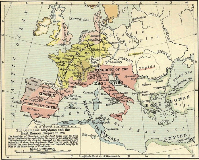
Map of the Germanic kingdoms and the East Roman empire in 526 C.E.—The headship of Emperor Theodoric and the East Goths (Ostrogoths) over the West Goths (Visigoths) is indicated by underlining the name of the latter in white. The colorings of the district occupied by the Alamanni are intended to show how checkered their career was. Of this district the area bordered in green corresponds roughly to that of the later duchy of Franconia. Also indicated are the kingdom of the Franks (yellow) and the kingdom of the Vandals (blue). In Britain, notice the pressure of the Angles and Saxons pushing the native Britons westward, into areas now known as Wales and Cornwall.

Click here to enlarge this image.
 
 
We recommend that educators check out these other free teaching materials our experts have created. Attila the Hun Biography Workbook Blank DIY Vertical Concept Map Clovis I of France Biography Workbook Roman Empire Map of 376 C.E. with Barbarian Migrations Alaric the Bold Biography Workbook
 
 
Barbarian Migrations Books and FilmsBarbarian Migrations Outlines and PowerPoints
  
Barbarian Migrations Maps and PicturesBarbarian Migrations Study Games
  
Barbarian Migrations MiscellanyBarbarian Migrations Worksheets
 
 
www.studenthandouts.comWorld HistoryBarbarian MigrationsBarbarian Migrations Images