Map of Louis XIV Acquisitions | Student Handouts
 Welcome to Student Handouts--www.studenthandouts.com! 100% free teaching materials for students in kindergarten through high school--lesson plans, worksheets, PowerPoints, outlines, interactive games, puzzles, and so much more!
 
Map of Louis XIV's Acquisitions
World HistoryAbsolute MonarchyGlobal Absolutism Maps and Pictures
 
 
Map of Louis XIV's Acquisitions
 
 
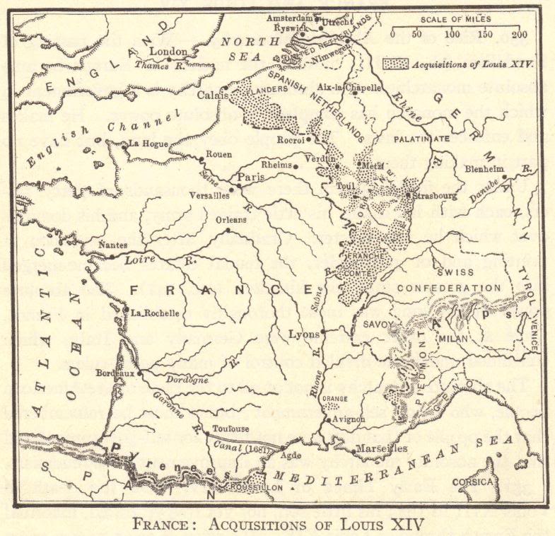
Map of France: Acquisitions of King Louis XIV. Important areas gained included parts of Alsace and Lorraine, which were disputed by France and Germany well into the twentieth century. In terms of size, the largest region acquired by Louis XIV was Franche-Comté (today's Departments of Doubs, Jura, Haute-Saône, and Territoire de Belfort), located at the Jura Mountains, one of the few heavily Protestant areas of France. Despite portions of Franche-Comté being ruled by the Germanic dukes of Württemberg for many years, Franche-Comté ("Free County" in English) is a Francophone region that borders French-speaking Switzerland.

Click here to enlarge this image.
 
 
You might also like... Leonardo da Vinci Biography Workbook George Washington Poetry Unscramble Map of Hapsburg Europe in 1560 Causes and Effects of the Cold War DIY Infographic Worksheet Polynesia Word Search Puzzle
 
 
Global Absolutism Books and FilmsGlobal Absolutism Outlines and PowerPoints
  
Global Absolutism Maps and PicturesGlobal Absolutism Study Games
  
Global Absolutism MiscellanyGlobal Absolutism Worksheets
 
 
World HistoryAbsolute MonarchyGlobal Absolutism Maps and Pictures