Maps and pictures are invaluable tools for high school World History students studying the rise of nation-states in Europe. These visual aids help students understand complex historical developments by providing a spatial and visual context that textual descriptions alone cannot convey.
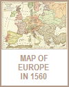
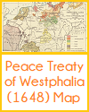
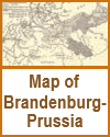
Maps, for instance, illustrate the changing political boundaries over time, helping students track the formation and expansion of nation-states like France, England, and Spain. They can visualize how these states consolidated power by annexing neighboring territories and how geographical features such as rivers, mountains, and seas influenced political boundaries and conflicts. Comparing maps from different periods allows students to see the dynamic nature of political borders and the impact of wars, treaties, and dynastic changes on the shape of Europe.
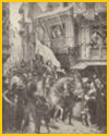
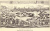
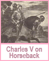
Pictures, including paintings, portraits, and historical photographs, offer insights into the cultural and social aspects of the rise of nation-states. Images of key figures, such as monarchs and military leaders, bring historical personalities to life and provide a face to the names in their textbooks. Artistic depictions of significant events, such as coronations, battles, and treaties, help students visualize these moments and understand their importance in the broader historical narrative.
By incorporating maps and pictures into their studies, students can better grasp the complexities of nation-state formation, appreciate the interplay of geography and politics, and engage more deeply with the historical material, making their learning experience richer and more comprehensive.
|