


| Map of Imperial Rome |
|---|
| www.studenthandouts.com ↣ World History ↣ Ancient Rome ↣ Ancient Rome Maps & Pictures |
 |
|
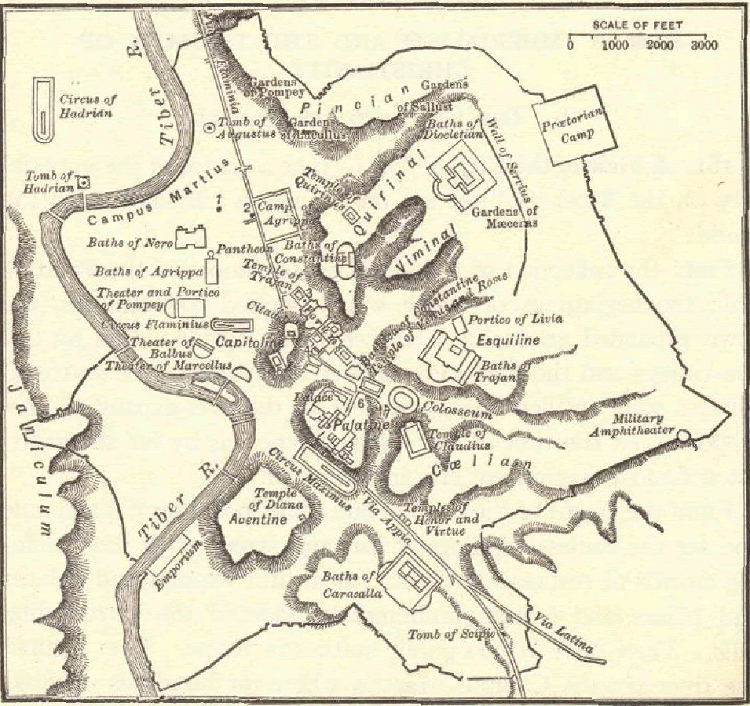
Map of Imperial Rome: The wall surrounding the city was begun by the Emperor Aurelian, 271 C.E. Click here to enlarge this image.
The topography of the ancient city of Rome was a defining feature of the city's layout, development, and daily life. Rome was situated on the Italian Peninsula, specifically on the Tiber River, and its topography consisted of a combination of hills, riverbanks, and low-lying areas. Seven Hills:
Low-Lying Areas: Rome's low-lying areas, such as the Campus Martius (Field of Mars), were used for various purposes, including military training, public gatherings, and recreational activities. Over time, this area also became a hub for Roman public buildings, including theaters, temples, and baths. Hills as Defensive Features: The hills surrounding Rome provided natural defenses for the city, making it more challenging for invading forces to approach. This topographical advantage was critical to Rome's security. Aqueducts and Water Supply: Rome's hilly terrain and the need for a water supply led to the construction of aqueducts, which transported fresh water from distant sources into the city. These aqueducts, along with the Tiber River, ensured a reliable water supply for the city's inhabitants. Urban Development: The topography of Rome influenced the city's layout and urban development. The hills often served as focal points for temples and public buildings, while the low-lying areas accommodated residential neighborhoods and markets. The combination of the seven hills, the Tiber River, and the low-lying areas created a distinctive and varied landscape for ancient Rome. This topography contributed to the city's unique character and had a lasting impact on its historical, architectural, and cultural development. |
 |  |  History Workbook") |  |  Biography Workbook") |  |
| Ancient Rome Books and Films | Ancient Rome Outlines and PowerPoints |
| Ancient Rome Maps and Pictures | Ancient Rome Study Games |
| Ancient Rome Miscellany | Ancient Rome Worksheets |
| www.studenthandouts.com ↣ World History ↣ Ancient Rome ↣ Ancient Rome Maps & Pictures |


